
Havering, London
Flat conversion drawings in Havering
Havering is a borough of owner-occupiers, with over half its land in the Green Belt and a planning desk that decides small schemes quickly but grants fewer of them. Our flat conversion drawings in Havering start at £1,195 including VAT, prepared by MCIAT chartered architectural technologists.
From £1,195 (VAT included)
- MCIAT chartered
- £2m PI insured
- LABC Partnered
- Fixed fees, VAT included
Request a fixed quote
How we work on flat conversion drawings
Seven steps from first call to approval.
Enquiry and constraints check
We check the property against conservation areas, listed status, Article 4 directions, tree preservation orders, flood zone and planning history. We choose the right route and send a fixed quote.
Measured survey
We survey the house on one datum: rooms, levels, boundaries, drains, trees and the neighbours' windows that the 45° and 25° tests depend on.
Design options
We model the house in Revit and show you options in 3D and plan, with the planning strategy and the precedents in your street.
Design frozen
You choose an option in writing. Nothing changes after this without your say.
Independent check
A second chartered technologist checks every sheet against the council's validation checklist and the policy. A senior review signs it off before anything is submitted.
Submission
We prepare the forms, certificates, fee and documents and submit through the Planning Portal.
Officer liaison
We answer the planning officer and make any amendments within five working days, at no charge until approval.
Free redraws until approval. Every drawing set is checked independently, and the checker is never the person who drew it.
Request a fixed quote
Quick, but selective: Havering's record on small schemes
Havering has no numeric subdivision rule that we can quote, so its decisions are the guide. In the latest twelve months it decided 306 minor applications, the class for fewer than ten homes, and decided 96.4 per cent inside eight weeks or an agreed extension, which makes it a very quick desk.
The grant rate is lower: 64.4 per cent of minor applications, against 85.9 per cent for householder work. Speed and selectivity together mean you hear quickly, and a weak scheme hears no sooner. We therefore put the evidence in the first submission: area schedule, daylight to the lower flat, access and storage.
The Local Plan was adopted in 2,021, and the borough publishes a Residential Extensions and Alterations SPD and a Heritage SPD, so check both.
Local figures for Havering
| Measure | Value | Period | Source |
|---|---|---|---|
| Minor application decisions | 306 decisions | 1 July 2025 - 30 June 2026 | assets.publishing.service.gov.uk |
| Minor applications granted | 64.4 % | 1 July 2025 - 30 June 2026 | assets.publishing.service.gov.uk |
| Minor applications decided in time | 96.4 % decided within 8 weeks or an agreed extended period | 1 July 2025 - 30 June 2026 | assets.publishing.service.gov.uk |
| Householder applications granted | 85.9 % | 1 July 2025 - 30 June 2026 | assets.publishing.service.gov.uk |
| Borough CIL residential rate | £151.52/m² (Zone A, North of A1306); £66.67/m² (Zone B, South of A1306) | 2026 indexed rate (permissions granted 1 Jan–31 Dec 2026); schedule rates £125 / £55 | havering.gov.uk |
| Mayoral CIL charging band | 3 MCIL2 charging band (1-3) | — | london.gov.uk |
| Mayoral CIL rate (indexed) | 30.3 £/m² (indexed, permissions granted in 2026) | — | london.gov.uk |
| Households living in a house | 76.7 % of households living in a house or bungalow (detached, semi-detached or terraced) | Census 2021 | nomisweb.co.uk |
| Owner-occupied households | 69.5 % of households owner-occupied (owned outright or with mortgage/loan) | Census 2021 | nomisweb.co.uk |
| Green Belt share of the council area | 53 % of council area covered by green-belt polygons | — | planning.data.gov.uk |
| Domestic gardens share of land (GLUD 2005) | 19.5 % of land that is domestic garden (GLUD 2005) | 2005 | data.london.gov.uk |
| Conservation areas | 11 named conservation areas published by the council | — | planning.data.gov.uk |
| Listed building entries | 146 list entries (Historic England, within the LPA boundary) | — | planning.data.gov.uk |
| Average price, semi-detached | 540,897 GBP | 2026-07 | publicdata.landregistry.gov.uk |
| Average price, flat | 251,321 GBP | 2026-07 | publicdata.landregistry.gov.uk |
| Local plan adopted | 2,021 | — | havering.gov.uk |
| Change of use of a building to one or more separate dwellinghouses, not more than 10: per dwellinghouse, from 1 Apr 2026 | 610 GBP per dwelling | — | ribblevalley.gov.uk |
| Supplementary planning document | Residential Extensions and Alterations SPD | 2011 | havering.gov.uk |
| Supplementary planning document | Heritage SPD | 2011 | havering.gov.uk |
| Households | 101,277 | Census 2021 (21 March 2021) | nomisweb.co.uk |
| Approved Document E 2003 incl. 2015, Table 0.1a | Separating walls 43 dB DnT,w+Ctr (min); floors and stairs 43 dB airborne (min), 64 dB L'nT,w impact (max) for dwellings formed by material change of use | — | gov.uk |
| Average price, terraced | 435,382 GBP | 2026-07 | publicdata.landregistry.gov.uk |
| Average price, detached | 841,116 GBP | 2026-07 | publicdata.landregistry.gov.uk |
| Householder decisions | 985 decisions | 1 July 2025 - 30 June 2026 | assets.publishing.service.gov.uk |
A blank value means the figure has not been published, not that there are none. Check your own address with the council.
Building regulations, layer by layer
The Approved Documents that shape most house projects, from structure to the application itself.
- A · Part A: structure
- Approved Document A: Structure, 2004 edition incorporating 2004, 2010 and 2013 amendments
- B · Part B: fire safety
- All dwellings: fire detection and alarm system minimum Grade D2 Category LD3 (BS 5839-6), mains-operated smoke alarms to BS EN 14604
- C · Part L: insulation
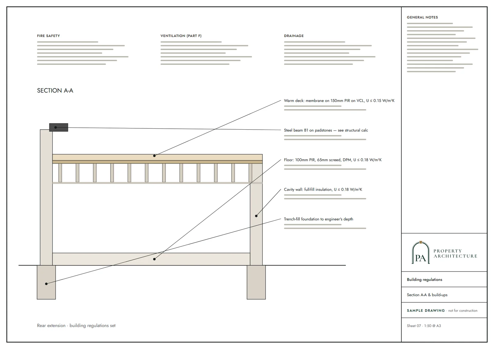
- New elements in existing dwellings, limiting U-values W/(m²·K): roof 0.15, wall 0.18, floor 0.18, windows 1.4 (or WER Band B), doors 1.4
- D · Part K: stairs
- 2.0 m clear headroom over stairs
- E · Full plans application
- Building control body must decide a full plans application within 5 weeks, or longer if agreed in writing
A borough of family houses
76.7 per cent of Havering's 101,277 households live in a house, and 69.5 per cent own their home. A semi-detached house averages about £540,897 and a flat about £251,321, so conversion margins are thinner than in inner London.
Green Belt covers 53 per cent of the borough, so a house on the eastern or northern fringe may sit under an extra layer of policy. Gardens are generous, at 19.5 per cent of the land. See architectural drawings in Havering for the constraints list.
Heritage, HMOs and levy in Havering
Havering has only 11 conservation areas and 146 listed entries, so heritage is a lighter burden than in the inner boroughs. It does have an Article 4 direction for HMOs, so a scheme of let rooms is controlled separately from flats.
The borough levy is zoned: £151.52/m² (Zone A, North of A1306); £66.67/m² (Zone B, South of A1306) Mayoral CIL band 3 adds £30.3 per square metre, indexed. The council fee is £610 per dwelling.
What the drawings include
A measured survey, then a Revit model, plans for every floor, elevations, sections, a block plan and the area schedule. Sound between flats follows Approved Document E (Separating walls 43 dB DnT,w+Ctr (min); floors and stairs 43 dB airborne (min), 64 dB L'nT,w impact (max) for dwellings formed by material change of use), detailed later in the building regulations drawings. A second chartered technologist checks each sheet.
Thin margins and how to protect them in Havering
At £251,321 a flat, Havering is a market where conversion margins are tight, and a design that wastes space can erase the profit. A terraced house averages about £435,382 and a detached about £841,116.
We start with the appraisal. Most Havering houses are family homes on big plots, and splitting them into two small flats may earn less than building a rear extension and keeping one larger home. Our job is to show you both options before you commit. The borough decided 985 householder applications in the latest twelve months, granting 85.9 per cent, so extensions are well trodden.
If conversion still wins, the tactic is simplicity: two flats, one shared entrance lobby, a bin store at the front and the garden given to the lower flat, with the upper flat taking a modest terrace if the roof allows. Larger schemes bring more levy, more sound separation and a longer programme. For the next step, see planning drawings in Havering.
The Havering process in brief
We start with a free constraints check covering conservation areas, Green Belt, trees and planning history. A fixed quote follows, then a measured survey and layout options in 3D. You choose one in writing, the design is frozen, and a second chartered technologist checks every sheet before submission.
Havering is quick, so respond fast to officer queries. If the council asks for amendments we redraw at no charge until approval, though we cannot promise the decision. After a grant, the same model supports the technical drawings for building regulations, so the builder works from one coordinated set.
Keep the paperwork tidy from the start. A single named contact for the survey, the design choices and the council correspondence stops instructions drifting, and it keeps the programme honest. We confirm each decision in writing before the drawings change, so the set the builder receives matches the one the council approved.
What you receive
Related pages
Other services in Havering
Flat conversion drawings nearby
Questions
How fast does Havering decide small housing schemes?
96.4 per cent of minor applications were decided on time in the latest twelve months.
Is Havering mostly Green Belt?
53 per cent of the borough is covered by Green Belt.
Which Mayoral CIL band is Havering in?
Band 3, the lowest, with an indexed rate of £30.3 per square metre.
Sources and dates
- assets.publishing.service.gov.uk, retrieved
- havering.gov.uk, retrieved
- london.gov.uk, retrieved
- london.gov.uk, retrieved
- nomisweb.co.uk, retrieved
- nomisweb.co.uk, retrieved
- planning.data.gov.uk, retrieved
- data.london.gov.uk, retrieved
- planning.data.gov.uk, retrieved
- planning.data.gov.uk, retrieved
- publicdata.landregistry.gov.uk, retrieved
- havering.gov.uk, retrieved
- ribblevalley.gov.uk, retrieved
- nomisweb.co.uk, retrieved
- gov.uk, retrieved
- gov.uk, retrieved
- gov.uk, retrieved
- gov.uk, retrieved
- gov.uk, retrieved
- legislation.gov.uk, retrieved
- Contains public sector information licensed under the Open Government Licence v3.0.
- Contains OS data © Crown copyright and database right 2026.
- Contains HM Land Registry data © Crown copyright and database right 2026. This data is licensed under the Open Government Licence v3.0.
- Contains Historic England data © Historic England 2026. Contains Ordnance Survey data © Crown copyright and database right 2026.

Tell us about your property.
We check the constraints, then send a fixed fee. Messages before 3pm get a reply the same working day.